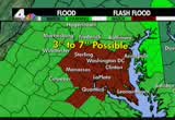
tornado watch area does cover eastern virginia, the district of columbia, northern virginia, and much of maryland, and the eastern shore. this tornado watch means conditions are ripe for individual storm to produce a funnel cloud. this is in effect until 1:00 this afternoon. along with heavy rain, more flooding likely later today, as well. highs reaching the mid 70s. right now, it's in the 60s to near 70. and then tomorrow, we'll be drying out. the rain can taper off and end by midnight tonight. blustery winds tomorrow with partly cloudy skies, highs reaching the mid 70s. then as we get into tomorrow afternoon and evening, we'll see they're getting quite chilly. only in the 40s on saturday morning. saturday and sunday afternoon, we'll have it into the mid 60s to upper 60s andt will be partly cloudy. another chilly start on sunday morning, and as we get into next week there could be some more unsettled weather moving our way with highs in the 6s to 70s by midweek. but again we do have a tornado warning in effect for southern maryland, it includes eastern st.ary's county, and southern c
 Live Music Archive
 Librivox Free Audio
 Metropolitan Museum
 Cleveland Museum of Art
 Internet Arcade
 Console Living Room
 Books to Borrow
 Open Library
 TV News
 Understanding 9/11